This article was done in collaboration with the weatherman himself, Maxwell!
Tropical cyclones (TCs) come in all shapes and sizes. Yet, there’s no denying that they’re each highly destructive phenomena at the very limits of what nature can throw at us.
TCs only form in specific ‘basins’, which are areas of open water where they’re able to rely on ocean heat content to strengthen or survive. Cold water As a result, only specific countries see consistent impacts from hurricanes.
Yet, there is the odd tropical cyclone which forms in strange, unexpected locations. “Medicanes”, the South Atlantic - these “irregular” basins sometimes output the weak tropical storm here and there, many never reaching hurricane status. Yet, the relative unpreparedness of the surrounding regions to deal with such a storm can compound damages and increase risks to human lives. Therefore, it is important for meteorologists to catalogue the formation of and paths taken by these abnormal tropical cyclones.
In this article, we’ll take a look at some of these cyclonic oddities. From cyclones that formed despite unfavourable conditions to strange tracks that wreaked havoc among seaside communities, each one of these cyclones tell us more about our unpredictable world and how we as humans must grow to adapt to it.
1: Cyclone Yaku
Anomalously high sea surface temperatures brought around by a high-amplitude Madden-Julian oscillation (the periodic, 30-day period variation of tropical sea surface temperatures), moisture from the Inter-Tropical Convergence Zone, enhanced westerlies and weak easterlies provided marginal conditions for the formation of a tropical low. Forming on March 7th, Yaku (meaning “water” in Quechua) was noted on the same day by Peru’s National Service of Meteorology and Hydrology (SENAMHI) as an “unorganised tropical cyclone”. It meandered off the coast of Peru for nearly two weeks, remaining close enough to deliver heavy rainfall. After moving away from the western coast of Peru, the “cyclone” dissipated on March 20.
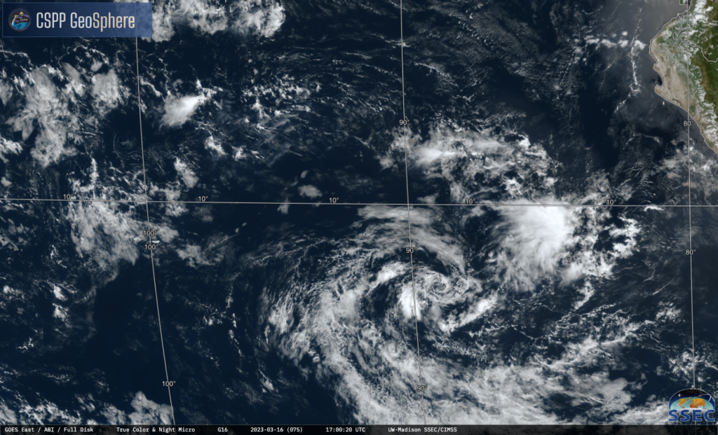
Though no more than a tropical low throughout its life, its formation in the Humboldt Current immediately turned many meteorological heads. Being a cold water current on South America’s west coast, the Humboldt Current has a mean temperature of just 16 degrees centigrade, typically far too low for tropical cyclogenesis. In addition, wind shear, the measure of how fast winds in a certain area are changing, is usually high in waters associated with the Humboldt Current; as tropical cyclones require winds to blow in one uniform direction to encourage spinning, this makes conditions off South America extremely hostile to tropical cyclones. It has been estimated that even a weak Yaku-like system occurs once every 40 years.
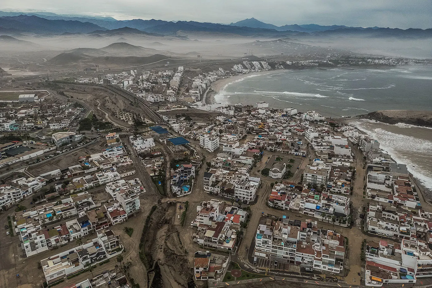
The predominantly coastal desert communities of Peru, unaccustomed to extended periods of tropical rainfall, were inundated by the outer bands of the large tropical low. This flooding led to landslides (called “Huaicos”), the most serious of which buried the town of Quiruvilca, though the town was evacuated before the storm came; elsewhere, at least eight fatalities were reported. The storm caused anywhere between 690 million and 4 billion USD in damages.
2. Hurricane Lenny
When hurricanes form in the North Atlantic, they typically take a path right through Hurricane Alley. Similar to Tornado Alley, “Hurricane Alley’ refers to the common apparent paths most hurricanes take as they are steered by the westbound trade winds. This path takes the hurricane all the way from Africa, to the Caribbean and finally the continental United States. As per the direction of the Earth’s rotation, air currents follow the westwards directions of Hadley Cells, which are found between the horse latitudes and the equator, or 0 to 30 degrees North. Though many hurricanes are inevitably swept up by the end of the Gulf Stream, heading eastwards thanks to the subtropical jet stream of Ferrel Cells, most meteorologists still expect hurricanes to travel westwards.
Except for Hurricane Lenny, that is. Not only did it follow a path that sent it barrelling into the U.S Virgin Islands, it was also the strongest November hurricane to occur in nearly 70 years. When a tropical low strengthened into Tropical Storm Lenny on November 13, 1999, the cyclone had already begun its eastward trek towards the Leeward Islands. Squeezed by an atmospheric trough to its north, the jet stream, typically at 30 degrees north, was forced downwards to 20 degrees north. This meant that atmospheric currents at the time all shifted towards the East, thereby propelling Lenny “the wrong way”. This would earn it the nickname of “Wrong Way Lenny”.
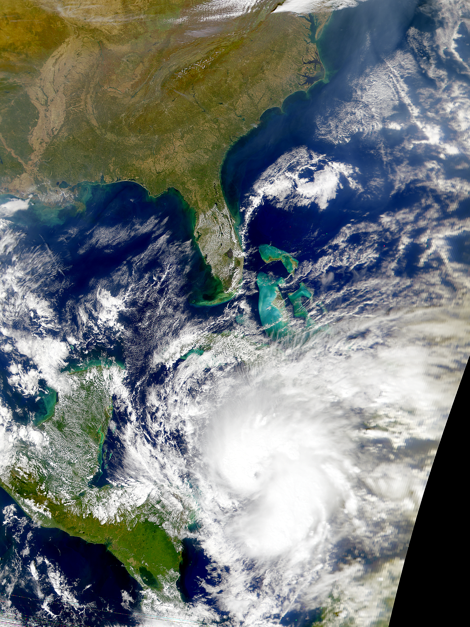
Lenny would then slowly intensify, reaching hurricane status as it passed just south of Jamaica, then rapidly intensifying just south of the Leeward Islands. It would make its first landfall on the island of St. Maarten with winds of 125 mph, below its peak intensity at 155 mph. A ridge to its northwest then forced Lenny to turn southeastwards, moving slowly across other Caribbean islands until it made its final landfall on Antigua on the 19th of November, weakening considerably due to the upwelling of cooler waters.
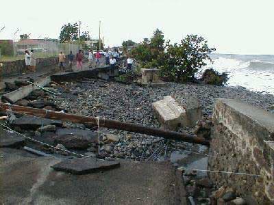
Throughout its lifetime, Lenny brought significant destruction to the Leeward Islands, leading to 786 million USD in damages and 17 fatalities.
3. 1996 Lake Huron Hurricane
Hurricanes require high, sustained amounts of ocean heat content to strengthen significantly, and therefore typically form in the open ocean. Cyclogenesis over freshwater bodies is almost unheard of, mainly as most large freshwater bodies are still too small or too cold to support cyclones.
So imagine my surprise when I learnt about the 1996 Lake Huron Hurricane. Yes, you read that right - a hurricane on the Great Lakes. Forming from a non-tropical low on September 11, 1996, it meandered across Lake Huron before dissipating on September 15. Throughout its life, it gained tropical characteristics and a distinct eye, though not fully shedding the large, swirling extratropical circulation that accompanied it.
The cyclone attained a peak intensity of 75 mph (enough to classify it as a category-1 hurricane), the subtropical centre of the cyclone never once interacted with land. Instead, it was its outer rainbands that brought flooding to the Great Lakes area, and no fatalities were recorded during its four-day passage over the lake.
This unique cyclone still stands as a testament to the unpredictability of our own planet’s climate. As the oceans warm up, cyclones like these may become increasingly common, decreasing the effectiveness of our models and putting more people at harms’ way to these types of natural disasters. It’s in our best interests to keep the planet intact as it is!
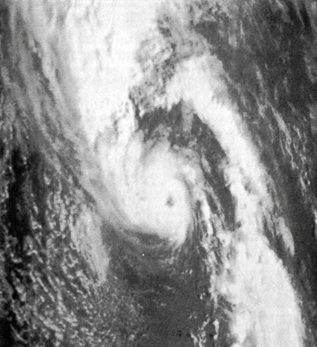
4: Cyclone Hinano
In the South Pacific, the majority of cyclones tend to form west of 150 degrees E - roughly the longitudinal coordinate of French Polynesia. In short, the lack of activity eastwards thereon is attributed to the lack of a notable Intertropical Convergence Zone (ITCZ) and strong prevailing trade winds, caused by the Southern Hemisphere Hadley Cell. Variations do occur depending on the evolution of the ENSO state (El Nino provides more favourable conditions out east and vice versa for La Nina), but this overall pattern remains very notable.
This is what makes Cyclone Hinano one of the most anomalous tropical cyclones in the modern satellite era. Its reported longitude of formation of 127 degrees east makes it the easternmost-forming tropical storm in the history of the Southern hemisphere - closer to the coast of South America than Australia.
Very little is known about the origins and history of the system due to the lack of satellite coverage at that time. Likely forming off a tropical wave detaching from the Intertropical Convergence Zone, it drifted polewards (southwards) as a result of the enhanced Hadley Cell from the prevailing weak La Niña pattern.
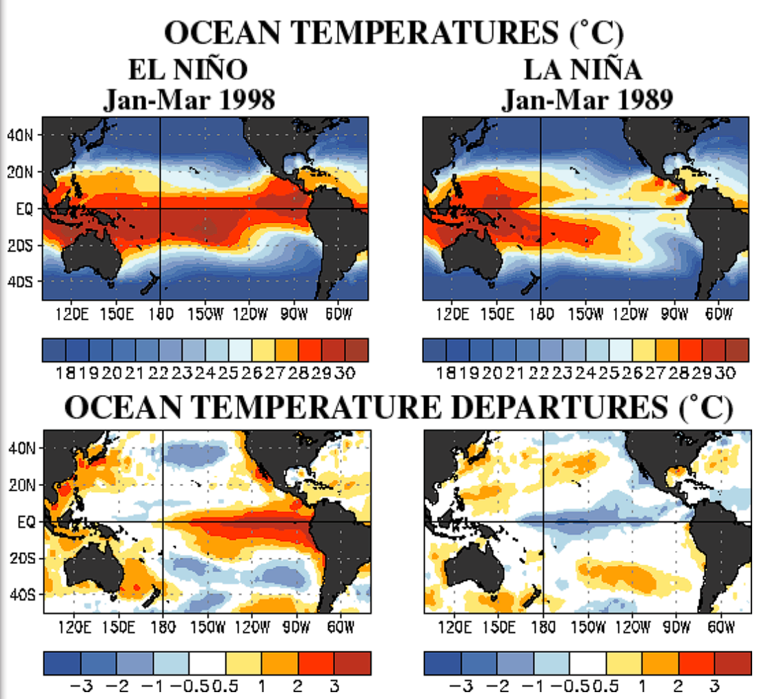
Encountering a tongue of anomalously warm sea surface temperatures, conditions allowed for the vortex to deepen and the wave envelope to become better defined. Drifting westwards along the periphery of a strengthening ridge to its south, unusually favourable conditions allowed the low pressure system to develop into Tropical Cyclone Hinano.
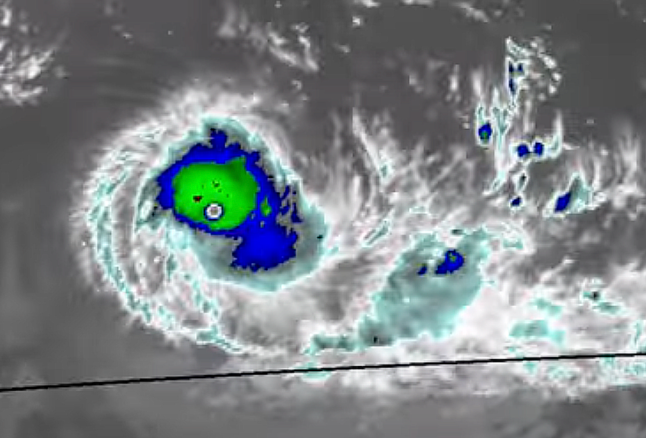
The centralized nature and lack of banding features associated with easterly waves expedited the quick strengthening trend of the system. Quickly developing a defined small eye with a robust eyewall, Hinano began to turn towards the south due to a trailing trough. There, Hinano reached its officially documented peak of 120km/h or 65kt on the Australian scale and 150km/h or 80kt on the SSHWS. Cooler sea temperatures and increasing wind shear plagued its journey to the south, and Hinano would eventually degenerate into a remnant low.
Similar to many historic storms, conventional intensify measuring techniques nowadays would give a much higher estimate. A quick Dvorak analysis determines a B embed, LG surround and WMG eye which would give a rating of T6.0. The persistence of this pattern over 6 hours reflects an intensity of around 215 to 220 kph, or 115 to 120kt - equivalent to a low end category 4 hurricane. In this area of the world, such systems are exceedingly rare - probably a multidecadal occurrence.
Systems like these demonstrate the beauty of meteorology - it is fundamentally a science bound by strict principles and conventions. But our planet is never static, and it is when these norms are broken that we are able to appreciate their significance.
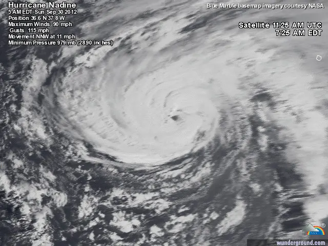
5: Hurricane Nadine
The North Atlantic is a rather small basin, only half the width of the North Pacific. The hotspots of tropical cyclogenesis are bounded by the area west of the Lesser Antilles - namely the Gulf of Mexico and the Western Caribbean. The median duration of a hurricane in the North Atlantic, resultantly, is not very long, barely exceeding one week.
Strong steering currents and the semi-permanent Azores High usually dictates a swift westward motion for most systems, either making landfall in the Americas and the Gulf Coast or recurving off to Bermuda and Newfoundland. Break these prevailing rules, and you get systems like Hurricane Nadine - the fourth most long-lasting hurricane in recorded Atlantic history.
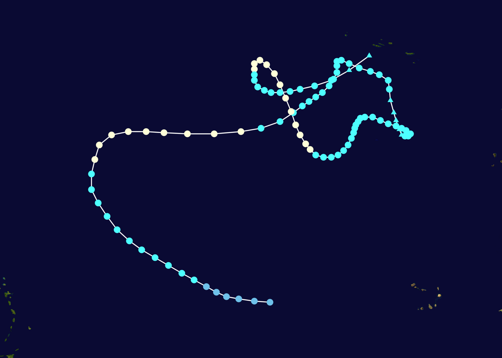
The origins of Nadine can be traced to a robust and vigorous tropical wave emerging off the coast of Western Africa on September 7. Passing by the Cape Verde, the favorable conditions of peak hurricane season promoted the development of a low pressure area. Increased definition of the system eventually led to the formation of Tropical Depression 14 on September 10.
Strengthening was impeded at first by repeated intrusions of Saharan dry air plumes, leading to a lack of convective activity and a dependence of the diurnal cycle. Rounding the south periphery of the ridge, the name Nadine was given on September 12.
As it curved along the ridge and travelled northwestwards, the small system rapidly coalesced. Convective banding led to the formation of a central dense overcast, and eventually a nascent eye (a primordial and transient eye-like structure caused by subsidence of vortical hot towers). Turning eastward over the open Atlantic, Nadine reached its first peak of 80mph on September 14.
An undercutting upper-level trough imparted wind shear into the system, destablizing the vortex and causing gradual weakening as Nadine turned north, then east. Nadine then surprisingly turned south, likely a result of an omega block as the previous trough blocked the trailing ridge. Eventually, Nadine degenerated into a remnant storm-force low, as its broadening circulation opened back up into a wave axis.
Drifting southwards, the low once again reached favourable conditions with warmer SSTs and lower wind shear. The arrival of another ridge removed the omega block pattern, as Nadine executed a clockwise cyclonic loop and started to travel westward. Another trough broke the prevailing pattern of ridge blocking, steering Nadine to the north for the final time. This is where Nadine redeveloped its ragged, nascent eye and reached a maximum intensity of 90mph.
Nadine would not be pulled to the poles just yet. Another blocking ridge caused Nadine to execute another cyclonic loop, looping anticlockwise and travelling eastwards once more. The jig was up for Nadine at this time - cold waters and dry air ultimately ripped the system apart and Nadine was no longer classifiable on October 4.
Its 8200 miles travelled and 22.25 days as a tropical entity engraves Nadine’s legacy in tropical meteorology. Even while post-tropical, Nadine became the third-wettest tropical system to affect the United Kingdom. Talk about impact!
6: The 1975 Pacific Northwest Hurricane
Tropical cyclone activity in the East Pacific is, compared to the North Atlantic or West Pacific, relatively confined. Main areas of activity are normally concentrated between the latitudes of Costa Rica and Baja California, and the longitudes of Pacific coastal Mexico and Hawaii. Too south, and the Coriolis force is too weak. Go too north, and the massive prevailing North Pacific High imparts too much dry air and wind shear. Longitudinally, it depends on the dominant ENSO and PMM (Pacific Meridional Mode) patterns. Negative states of both result in hostile conditions out west past Hawaii through enhanced trade winds which misalign the vortex of a tropical system. Put all of these together, and you get the conventions of a Pacific hurricane season - westward-moving tropical systems that form after emerging off Central America from propagating tropical waves or Central American Gyres. They strengthen gradually as they drift westwards, often reaching peak intensity between Mexico and Hawaii. Afterwards, they slowly lose steam and fizzle out over the open Pacific, seldom making landfall.
These conditions would dictate Hurricane Ilsa’s lifespan - peaking as a category 2 hurricane off coastal Mexico, and then weakening and dissipating to a remnant low as it drifted westward.
In September of 1975, the regimented hostility of the subtropical Pacific temporarily gave way for an anomalously favourable pattern. The remnants of Ilsa continued in a northwestward direction, maintaining organisation and a distinct circulation. The interaction of Ilsa’s remnants with an upper level trough generated a new low pressure area and allowed the system to develop subtropical characteristics. It would be at the latitude of Southern California and the longitude of Hawaii that the warm waters caused the formation of a subtropical cyclone, which was not named due to the CPHC’s (Central Pacific Hurricane Center) relative lack of technology and tracking software. Whether or not the system can directly be attributed to Ilsa remains uncertain - a similar case occurred with Lee II in 2017.
Turning to the north from an incoming trough, the system likely converted into a fully warm-core system associated. This heat engine that releases latent heat from the center of the system is associated with tropical cyclones, a remarkable feat for its location. Enhanced outflow from the trough accelerated its intensification rate, allowing the development of a shallow eye in the system and its upgrade to a minimal category 1 hurricane with winds of 120kph or 65kt. However, Like the house in gambling, the jets always win. Soon, blasting massive wind shear took hold over the system as it moved into colder waters, ultimately turning extratropical around 500 kilometers southwest of Juneau.
What a fascinating moment of meteorological history it is, only made more admirable considering how it took 5 years for the Central Pacific to produce Hurricane Hone in 2024.
Sources
- https://cimss.ssec.wisc.edu/satellite-blog/archives/51190
- https://journals.ametsoc.org/view/journals/clim/38/4/JCLI-D-24-0198.1.pdf
- https://www.wpc.ncep.noaa.gov/tropical/rain/lenny1999.html
- https://www.cpc.ncep.noaa.gov/products/analysis_monitoring/ensocycle/ensocycle.shtml
- https://www.youtube.com/watch?v=7Lvi8mRd7QI
- https://en.wikipedia.org/wiki/File:Nadine_2012_path.png
- https://wavetrain.net/category/blogs/techniques-a-tactics/
- https://en.wikipedia.org/wiki/1975_Pacific_hurricane_season#/media/File:Unnamed_Hurricane_(1975).PNG
.PNG)
Like what you see? Feel free to subscribe to receive updates whenever we post.